

Ontario experienced record-breaking rainfall in April. Coupled with the spring thaw, communities across the 705 experienced water levels that flooded roads, homes, and businesses. While we’re not in the clear yet, high waters have receded across much of the region.
Residents took to social media to post pics and video, and comment on the flooding.
Catharine Inniss: If it feels like Muskoka has had a few too many “rare” floods lately… you’re not imagining things. As of this afternoon’s provisional Water Office readings (April 27), Lake Muskoka at Beaumaris is down about 14.7 cm/ 5.8 inches from its April 23 peak. And Lake Rosseau at Port Carling, which feeds into Lake Muskoka, is trending down too. A “100-year flood” doesn’t mean it only happens once every 100 years – it means there’s roughly a 1% chance of that level of flooding in any given year.
But when severe floods keep happening close together, it raises a bigger question: are the assumptions behind our flood planning still realistic?
Ed Boutilier: Flooding in Muskoka isn’t caused by one thing and it’s not as simple as blaming dams or development. The reality is that this is a massive, connected watershed where water flows from a vast network of upstream lakes and rivers into Lake Muskoka and eventually out toward Georgian Bay. Climate change is now adding more pressure to that system, with more intense rainfall and unpredictable snowmelt events.
When those conditions hit at the same time, water arrives faster than it can leave. The system can manage timing, but it has limits and all that water still has to pass through a narrow bottleneck at Bala, down the Moon River, and out to Georgian Bay. When that outlet can’t keep up, water levels rise quickly and flooding becomes unavoidable.
Improving how the system is managed can help reduce impacts, but it does not change the underlying constraint. Meaningful reductions would require major structural changes to how water is stored or moved across the watershed, such as large scale storage or diversion infrastructure. Even then, these kinds of flood events can be mitigated, but not eliminated.
Heather Scott: High water in Muskoka is one thing. This level of damage is another.
Yes, we’ve had rain and snow melt, but this didn’t have to be this bad. Water management matters. And when it falls short, property owners pay the price. We can’t control the weather, but we can manage it better. Muskoka deserves better!
Water levels are regulated by The Ontario Ministry of Natural Resources, taking into account factors such as power generation, marine habitat, recreational objectives and flood risk. After catastrophic flooding in 2019, an independent review emphasized that dams in central Ontario, including those in the Muskoka watershed, are not flood control structures.
Muskoka resident Martin Ford has started an online petition calling on the province to “reassess and overhaul the Muskoka Watershed plan”. The petition states “Despite decennial plans and promises, the Muskoka Watershed plan continues to fail, bringing endless devastation and displacing families, destroying property. We have experienced enough struggles due to inadequate management and constant failures in addressing the root causes of these floods.”
Muskoka District Chair Jeff Lehman told CTV News that technology deployed this year has meant that no roads were closed in the region due to flooding and only four homes had to be evacuated.
“I have heard a lot of concern from people over the past couple of weeks about how water is managed,” he said. “I do think those plans need to be updated for the current reality.” (Quote Source: CTV News)
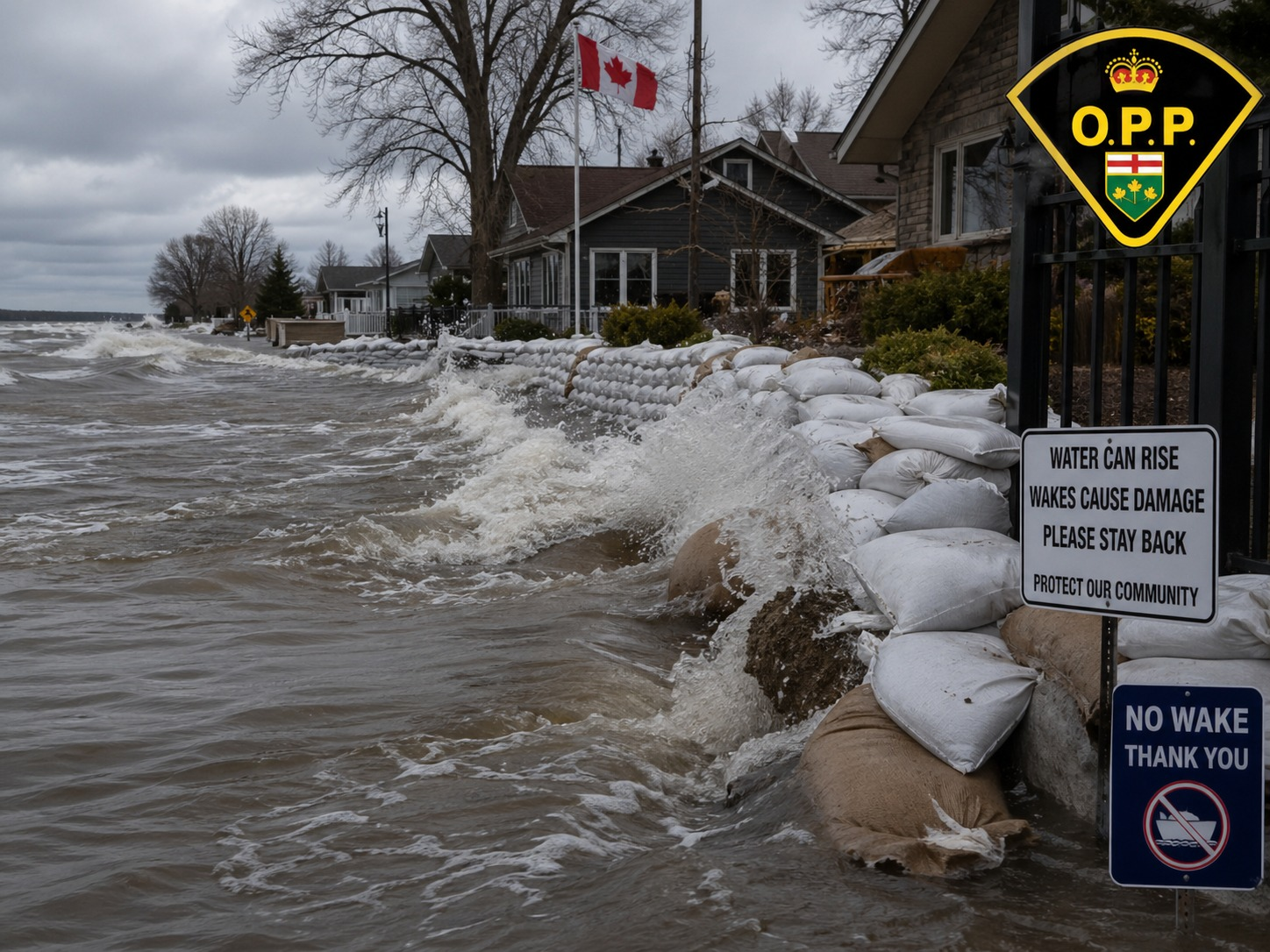
Many municipalities provided sandbags to stem the flooding. While water levels are receding, authorities are warning residents to stay off the water as debris, garbage, and even displaced docks and boating equipment are dealt with.
On April 29th, OPP – North East Region posted to facebook:
Due to recent flooding, the Nipissing West OPP is advising that water levels on many local waterways are higher than normal and reminding all boaters and personal watercraft operators to use extra caution and be respectful of others while enjoying the water.
Many waterfront property owners are currently using sandbags to help protect their homes, docks, and shorelines from rising water levels. Large wakes created by speeding boats and personal watercraft can disrupt these sandbags, reduce their effectiveness, and cause additional flooding and property damage.
Higher water levels can increase the impact of waves and wakes, causing significant damage to docks, boats, shorelines, and other private property. These waves can also create dangerous conditions for swimmers, paddlers, and other water users.
Please reduce your speed, especially near shorelines, docks, and residential waterfront areas. Operating too fast or too close to shore not only increases the risk of damage, but can also put others at risk.
Boaters are reminded to respect waterfront property owners and operate responsibly. Depending on the circumstances, causing damage to another person’s property through careless or reckless operation may result in charges, including mischief under the Criminal Code.
Safe and respectful boating helps protect our communities and keeps everyone safe on the water.
On April 29th, Bracebridge issued a news release updating their efforts to reopen roads that had been closed due to flooding. They are also advising residents to be cautious around waterways.
As snow melts and water levels change, residents are reminded to exercise extreme caution around rivers, lakes, and drainage courses.
- No ice is safe ice. Warmer temperatures and precipitation will weaken ice conditions;
- Stay away from fast-moving water and unstable banks, as they can collapse without warning;
- Keep children and pets away from all water bodies and ice-covered surfaces, as ice can quickly become unsafe;
- Exercise extreme caution when using forest access, gravel or secondary roads as they may be prone to soft areas;
- Do not attempt to drive through flooded areas. Even shallow water can be hazardous and unpredictable; and
- Be prepared. Have an emergency kit prepared with the items you and your family need to sustain themselves for a prolonged period of time.
Public Works crews continue to monitor changing weather conditions.
Residents and seasonal property owners can use the Muskoka GeoHub app to see how flooding may affect properties. The hub provides flood mapping in 2D and 3D, monitors current lake levels, and shows how rising water levels may impact your shoreline.

